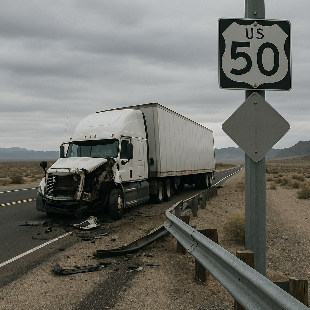
Truck Crash Danger Zones on US-50 in Nevada
Overview of the Nevada Location or Highway Segment
Stretching over 400 miles through the heart of Nevada, US-50 is a critical east-west highway traversing some of the state’s most remote and dramatic landscapes. Dubbed “The Loneliest Road in America,” US-50 slices through mountain passes, open desert valleys, and small towns like Ely, Eureka, and Fallon before crossing into California or Utah. While the solitude and stunning vistas attract adventurers and travelers, this very isolation can create serious challenges—especially for large trucks moving freight across Nevada’s vast interior.
Certain segments of US-50 have become recognized as danger zones for truck crashes. Long, desolate stretches between Ely and Fallon and even the route west of Fallon toward Carson City present unique hazards. The Nevada Department of Transportation (NDOT) and regional safety initiatives have identified these sections as areas where truck-related accidents occur at higher rates compared to other parts of the state’s highway network. Understanding why US-50 is prone to truck crashes and where the most dangerous zones exist helps highlight the importance of ongoing safety efforts.
Why Truck Accidents Are More Common in This Area
Commercial trucking is essential to Nevada’s economy, moving goods between Salt Lake City, Central Nevada, and the ports of Northern California. However, several factors collide on US-50 to make certain areas more susceptible to truck accidents than others.
First, the prolonged isolation can lull drivers into a false sense of security or lead to fatigue. The absence of towns, truck stops, or rest areas along long segments can contribute to drowsy driving—a known risk factor for crashes involving large vehicles. Additionally, the region’s notorious crosswinds, especially in open valleys, can push high-profile trucks off course or even overturn them.
Weather also poses a significant danger. During winter, US-50 is subject to sudden snowstorms and black ice, particularly on higher passes like the stretch near Austin Summit and areas east of Ely. In summer, sun glare, heat shimmers, and the mirage-like quality of the endless highway reduce visibility and spatial judgment.
Compounding these challenges, US-50 sees a unique blend of traffic: experienced truck drivers, local commuters, tourists unfamiliar with the terrain, and the occasional wild horse crossing the roadway. When these factors converge, incidents involving large commercial vehicles become more likely.
Road Design Factors that Influence Crashes
Much of US-50’s alignment in Nevada echoes historic stagecoach routes—direct but dictated by the terrain rather than modern safety standards. The physical features of the highway can turn small driving errors into serious incidents for trucks:
– Single-lane Segments: For much of the route, US-50 is a two-lane, undivided highway. The lack of median barriers increases the risk of head-on collisions if a truck veers out of its lane, whether due to fatigue, wind gusts, or evasive maneuvers to avoid wildlife.
– Steep Grades & Sharp Curves: Especially around Austin Summit (elevation 7,484 feet) and New Pass Summit, the highway’s incline and hairpin turns can prove challenging for trucks, particularly when carrying heavy loads or descending at higher speeds. Brake overheating and “runaway” situations have been documented in these zones.
– Narrow Shoulders & Limited Pull-Offs: Emergency escape or stopping zones are few and far between. When trucks encounter mechanical trouble or drivers need to rest, options for pulling over safely are severely limited.
– Unpredictable Road Surfaces: Despite maintenance efforts, some areas of US-50 may experience rapid weathering—surface cracks, potholes, or debris caused by flash floods and windstorms. These conditions can compromise a truck’s stability, especially when encountered unexpectedly.
Traffic Patterns and Truck Volume Considerations
The volume and makeup of traffic on US-50 change over its length and by season, with several factors affecting truck crash danger:
– Variable Truck Volume: Key logistics corridors, such as those near Fallon and through Eureka County, see concentrated truck activity, especially at night when drivers aim to avoid the hottest part of the day. This nocturnal volume can result in tired drivers and reduced reaction times.
– Tourist Season Increases: During summer, the highway carries higher numbers of recreational vehicles (RVs), motorcyclists, and tourists unfamiliar with desert driving or the speed and stopping distance of large trucks. Close encounters between disparate vehicle types raise accident risk.
– Passing Dilemmas: Long, flat stretches often tempt faster motorists to pass slow-moving trucks. These maneuvers, complicated by limited sightlines and potentially impatient drivers, have led to numerous sideswipe and head-on incidents east of Fallon and near Eureka.
– Agricultural and Mining Traffic: Local industries contribute heavy, slow-moving vehicles to the mix. Sudden speed differentials, particularly on grades or approaching active mining entrances, can catch out-of-state truckers and other motorists off guard.
Speed limits may vary, but with open expanses and few enforcement areas, both trucks and passenger vehicles occasionally exceed posted limits, further compounding the risk of high-speed crashes.
Safety Awareness Considerations
The unique dangers facing trucks on US-50 in Nevada form the focus of numerous NDOT campaigns and community awareness efforts. Recognizing the danger zones does not eliminate risk, but it does encourage all road users—including truck drivers, local businesses, and travelers—to heighten their awareness in known trouble spots.
Signs alerting drivers to frequent high-wind areas, wildlife crossings, and impending steep grades are prominent around identified danger zones, such as Austin Summit and the sections between Fallon and Ely. State troopers and road maintenance crews monitor these areas and may set up temporary advisories during adverse weather or special events.
Outreach initiatives often provide information about the locations of limited fuel and rest facilities—vital knowledge for truck operators managing hours-of-service restrictions. Community efforts, such as the distribution of maps highlighting problematic segments and seasonal hazard tips, supplement official signage.
Crash statistics and “near-miss” reports are regularly reviewed, allowing state agencies to recommend potential improvements, such as rumble strips, expanded runaway truck ramps, or the addition of passing lanes in high-risk segments.
For all drivers, heightened vigilance is encouraged in areas where truck crash danger peaks: steep descents like Austin and New Pass Summits, exposed valley stretches west of Ely, and the busy corridor near Fallon.
Neutral Closing Paragraph
The challenge of truck safety on US-50 in Nevada reflects the intersection of geography, history, and modern transportation demands. As commerce continues to flow across this isolated corridor, recognizing the roadway’s specific dangers helps shine a light on ongoing efforts to make travel safer for everyone. Whether crossing the sagebrush sea in a big rig or a compact car, understanding the unique risks of “The Loneliest Road in America” is an important step toward sharing Nevada’s highways responsibly and safely.